More from Peter Delow‘s series on HS2 Ltd’s cancellation of the Euston station rebuild. Originally published here.
I suspect that for those living within the shadow of the drab grey walls of Euston Station the key aspect of the announcement of a change in plan for the London terminus for HS2 is what impact, if any, it will have on the need to demolish homes and businesses in the area. Unfortunately the HS2 Ltd press release says nothing at all on this matter, and I have been forced to resort to interpreting the drawing of the revised station layout that HS2 Ltd issued with the press release.
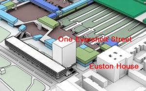
Lovers of seventies functional architecture will be overjoyed to see that, according to the HS2 Ltd drawing, the One Eversholt Street Tower will be retained. Those of us who would have rejoiced at its passing might feel compensation in noting that the other two office blocks on the forecourt are to go.
Euston House is also shown on the drawing as a survivor. In the document HS2 Safeguarding and Property & Compensation Consultation maps: location-specific notes on draft safeguarded area, which was issued earlier this year, we were told that Euston House may have to be demolished for “possible access to [the] underground station”. A local source tells me that this is still the case, so I am a little perplexed to see the building depicted on the HS2 Ltd drawing.
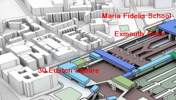
The Royal College of General Practitioners will be relieved that the new plans do not require the demolition of any of 30 Euston Square. This will also save the taxpayer a good few million pounds in compensation payments; Grade II* listed Neo-Grecian style buildings from the Edwardian era do not come cheap.
The western wall of the new Euston Station annex does not appear to extend any further into the community than the previous design, so there should be no increase to the list of buildings required to be demolished in this area. Two buildings where there was a doubt about the future are shown on the drawing as surviving; these are the North Gower Street building of the Maria Fidelis School and the Exmouth Arms public house. These two buildings are shown within the safeguarded zone on the drawings that were issued for the Property and Compensation consultation earlier this year. It is my understanding that the thinking at that time was that the site that they occupied might be required as a construction compound.
However, Maria Fidelis is a split-site school, with campuses on both the west and east sides of Euston Station. Construction work will not only be uncomfortably close to the North Gower Street site, but the construction site will act as a barrier to movement between the two sites. It seems very unlikely, therefore, that the school will be able to continue to use the North Gower Street building.
The nearby derelict National Temperance Hospital will, it appears, be demolished, but there is no sign on the drawing of the replacement social housing that had been mooted for the site. This is not unexpected as the Camden New Journal carried accusations that HS2 Ltd was “back-tracking on a pledge that council homes would be built on the site” in an article published last year
Nothing is shown on the drawing to indicate that any portion of St James’s Gardens will be retained, other than what appears to be a small patch of “token” grass.
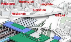
Where the drawing of the new proposal does give me cause for concern is in the depiction of the way that the high speed platforms are now required to extend much further northwards, and the impact that this may have on the Regent’s Park Estate.
The Chairman of the Euston Community Forum, Robert Latham, appears to share my concern. He is quoted in an article that was published in the Camden New Journal in March 2013 as fearing that the proposals could mean disruption extending “deeper into the Regent’s Park Estate”.
I have matched the blocks of flats that are depicted in the HS2 Ltd drawing against the plan of the estate as it is today and four appear to be missing. These four include the three blocks already scheduled for demolition, Ainsdale, Silverdale and Eskdale, but Cartmel, which I understood was spared by the original plan, is also not shown in the HS2 Ltd depiction. Should this omission be intentional, and not merely an oversight, then the loss of Cartmel would add another 69 dwellings to the demolition list. Also a fifth block, Coniston (24 dwellings), appears to be perilously close to the edge of the excavation required to accommodate the extended throat.
Now I have a fairly low opinion of the way that HS2 Ltd treats local communities, but even I would be surprised if news of the loss of a further block of flats was being deliberately suppressed. I am inclined, therefore, to the view that the HS2 Ltd drawing must be in error. However, any doubt about the future of Cartmel must be cleared up by an urgent clarification from HS2 Ltd; I trust that local representatives will ask the appropriate question.


Remember this project was not planned but dictated. London to Birmingham in shorter time. Not there is a freight and commuter issue on the south approaches of Wcml and Ecml and property on British Rail and Treasury Books. The proposal of incremental changes to heathrow because of time and funding of alternative sites argument by T S C could be applied to Network Rail. The argument
by 51M and others missed the opportunity to include the 3 radial route wcml mml and ecml in the plan and also
to extend the options. Now phase 2 areas are starting to be more realistic and asking what else is possible with less
Damage. Stop HS2 was not matched with
How else can the situations be resolved