
Spot the Difference is amusing when it is a game played during a wet half term holiday by bored school-kids. It is not amusing when it is part of an official environmental consultation.
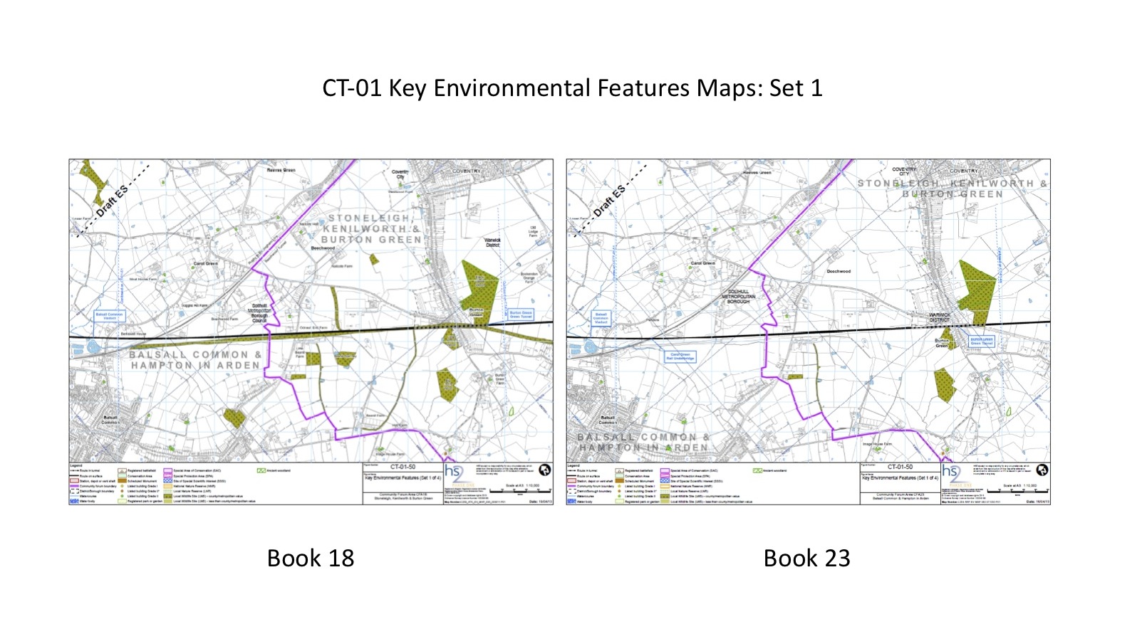
Shows differences in map CT-01-50 in CFA map book 18 and book 23
Stop HS2 was sent the above image recently, showing the different amounts of detail for the same map in the consultation documents for CFA Map Book 23 (Balsall Common and Hampton in Arden) and CFA Map Book 18 (Stoneleigh, Kenilworth and Burton Green).
The map – CT 01-50 – in the Balsall Common community forum area version shows significantly fewer environmental features for Balsall Common than are in the map book for a completely different area.
This is unacceptable: people in Balsall Common and Hampton in Arden should be able to use these books for their community forum area in the expectation that all the relevant data is available in the document they downloaded.
As our supporter said:
“The only justification for the environmental features to be different on the two maps would be if the features not in the area were grey/missing (e.g. Black Waste Wood in Burton Green not highlighted in the Balsall book, and vice versa). However here it simply that the Balsall Common book shows nothing at all in its zone and only some of the features over the border.”
But once again, in an important matter for the consultation, HS2 Ltd have got it wrong.
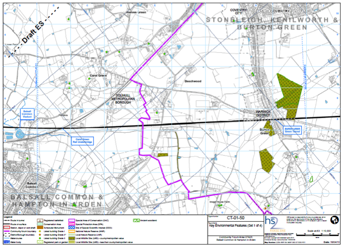
Map CT-01-50 in CFA map book 23 (Balsall Common and Hampton in Arden)
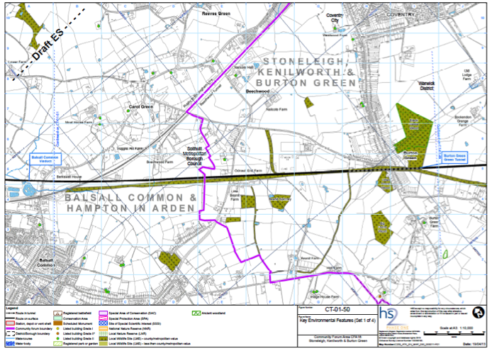
Map CT-01-50 in CFA map book 23 (Stoneleigh, Kenilworth and Burton Green)
PS We are collecting problems like this: if you come across problems with the consultation, please email challenge@stophs2.org.
Dont tick just the boxes for the Draft ES but also better to state the concerns.
Reviewing the Map documents for a number of areas the following issues are noted and you may wish to add to this list of omissions and additions not fairly represented:
Examples of omissions and issues found to date and subject to ground checks are:
1. The Twyford maintenance line not shown
2. The Waddesdon Bypass not shown
3. The Aylesbury Little Kimble changes not shown
4. The safeguarding widths and areas not shown
5. The spoil heaps not provided with references and material tonnages including road and other transport movement estimates.
6. The agricultural land designations not relating to realities.
7. No vertical representations of the network power, feeder and autotransformer area particularly near to Quainton and Sedrup and Fleet Marston with the name Putlows.
8. Land loss for the ponding areas to accomodate runoff with contaminants not sized and no presented basis for the determination of these with no overflow arrangements. This is an extra land loss for some land area. Balancing ponds is a strange PR phrase.
9. Embankments not sized and poorly represented in photograph presentations as the loss of horizon is related to distance from the obstructions. No volumes provided.
10. Not representing the communities the HS2 is leaving deterimentally impacted. Dull winter photos hiding the caternary structures and the cabling. Lack of representation of the pictorial areas and social and farming and livestock and wild life by sterilised dark images. No cricketers on the pitch.
12. Sound mapping at up to 2Km boundary from so few sites used for the measurements and no proof of how the contours were arrived at. Could be a watercolouring by Hockney or another but not derivable to such contouring.
13. 70 limits not representing passing disturbances. What peaks for one and two trains. No nightime limits for the IMD at Calvert.
14. Missing archaeological areas.
15. Some construction roads not showing total impacts and not the entire requirement for land and loss and congestion.
16. Still the use of the thin black boundary line not representing the construction and blighted areas for the 60m and 120m each side of track.
17. Far from the full story.
Would the parish councils and others please keep note of the key matters from the roadshows and from the follow ups to ensure that HS2 and DFT and others are made aware of the reasons that this project is not passing the grade at each stage and let all know what has been identified as concerns please.
Given the EIS work and the promise of dynamic and representation of life now, during and after this Draft Environmental Statement is not complete work with the sequences of images being minimal and the drawings being arranged with different scales and juxtapositions to lack flow.
Went to the Cubbington Consultation Farce.Well done to those who braved the rain to man a stop HS2 stand .I told the HS2 people that I was not Impressed by their advertising the events for Chalfont St Giles area instead of Southam area.I said that I should not be supprised at the
bad organisation because of the mistakes made in the past but I was not impressed.One Lady asked a Question was passed to a person who supposedly could help her only to be passed back to the person she first spoke to.She wished to know how many years before people
could get compensation and they just said they didn’t know.I can understand to some extent but they could have asked her where she lived
etc.It was just showed that they were happy to take money for being there but were not going to put themselves out.HS2 had filled the small carpark and as it was very wet and hard to park nearby I am sure people turned away.The screen with maps was difficault to use and unless you wanted to spend hours on it hard to decide what it was all about not having that sort of education.I will attend the Southam one on the 8th june .Meanwhile I have a lot of reading to do.